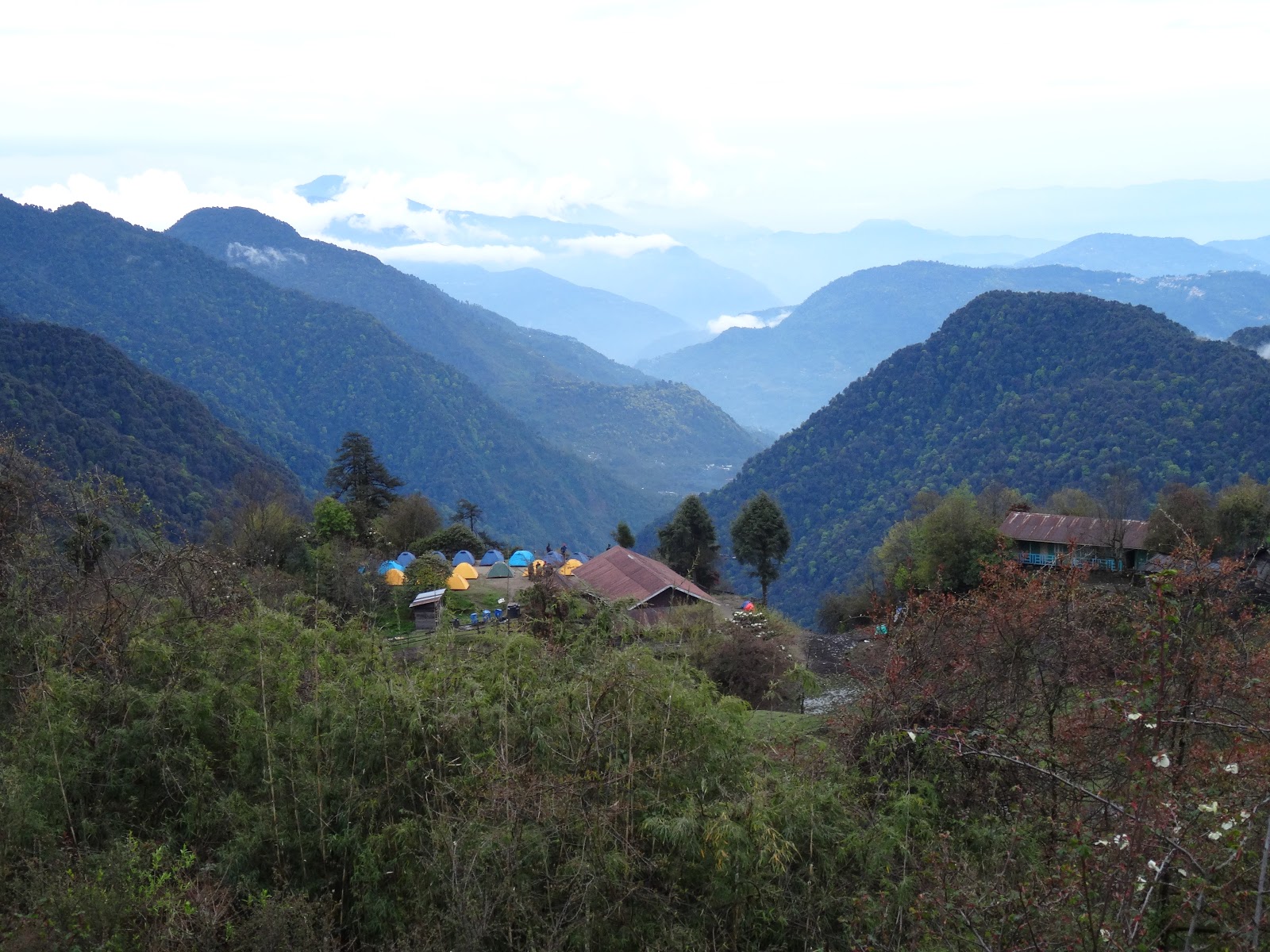
Saturday, March 25, 2017

Goeche La trek - May 2015. A photo log


April 26th:

The plan is to trek to Goeche La starting today. We are denied permission to enter the Kanchenjunga National Park because of the earthquake that hit eastern Nepal the previous day causing devastation in Kathmandu and surrounding areas including the Everest Base Camp. We spend the day roaming around Yuksom.

Our route is through Tshoka, Dzongri, Cockchurong, Thangsing and Lamuney
 
April 27th:

First day in Kanchendzonga National Park. I make first sightings of several beautiful birds. Here is one.

Striated Bulbul


Lush green landscapes all the way

April 28: Trek to Tsokha (2950 m)


Bird of the day! A Verditer Flycatcher
View of our camp at Tshoka
April 29: To Dzongri (3950 m)


April 30th: Dzongri to Thangsing

Dzongri in the morning after overnight snowfall
Marching in fog
May 1st: Thangsing (3930 m) to Lamuney (4200 m) along the Prek Chu

Kanchendzonga from Thangsing viewpoint

Basking in the sun
The trail by the Phrek Chu

My first sighting of the Grandala !

May 2nd: To Goeche la and back to Thangsing

Sunrise (4.54 am) on Kanchendzonga near Goeche La
5.12 am : Kabru dome, Kabru S and N and Kanchendzonga

5.16 am at closest viewpoint
Samiti Lake (4300 m) from where Phrek Chu flows
Samiti Lake
Spot Winged Grosbeak

My first clear sighting of a Grosbeak on the walk from Samiti lake to Thangseng!

May 3rd and 4th: Return to Yuksom

Approaching Tsokha after a long march on May 3rd
May 5th:

Back in pretty Yuksom

Himalayan Trek 12, May 2015

My Manimahesh Yatra - June 2016

Manimahesh Peak on a June afternoon


Himalayan Trek 16, June 2016


Sham Valley, Ladakh - trek diary from Aug 2013

Fields of Turutse

Background

The Sham Valley trek is considered a "baby trek" and recommended as a first trek for acclimatization for visitors to Ladakh who intend to attempt treks over high passes. Two days after I flew into Leh, I decided to do this trek in preparation for a later trek in Markha Valley. The plan was to do the trek alone, but as it turned out I had at least one companion all along the way.

Purab's house

Day 1 Leh to Tarutse

The 4 pm bus to Likir from Leh is jampacked. Since I had boarded the bus way before its departure time, I had a seat. In the bus I befriend an Israeli who is also headed for Likir. We reach Tarutse at 6.30. It turns out by a happy coincidence that the daughter of a homestay owner is also on the bus. Purab Dorje, a tenth class student, guides us to her home. We have ceremonial tea with the Bhutia family on the low seating with a bowl of Apricots placed in front of us.

Purab we find out studies in Leh and stays in a hostel. She knows Bhote, Hindi and English. Her father is a carpenter. She is the eldest of 3 siblings.

Purab with her grandmother and nieces
There is a long evening ahead of us and Purab volunteers to take us to her uncle's house which is close to the Likir monastery. We get a great welcome in the house where several generations - Purab's grandparents, aunts and uncle and nieces and nephews - are living together. Purab's uncle is a soldier and her aunt teaches in Leh. Two other uncles are Lamas by choice. It is still light and we get a chance to see a watermill which is used to grind roasted barley.

Back at the homestay, dinner consists of butter tea and sattu followed by a stew of wheat momos, vegetables and milk served on the characteristic low tables and shared with family. I share the bedroom with Uri and a Frenchman who has been laid up by diarrhea.
(The homestay in Tarutse is run by Kunzang Dolma, phone 9469448973)

Likir Gompa
Day 2: Tarutse to Sumdo

We begin the day with an intended quick visit to the Likir Gompa losing the way midway. Uzi has a running stomach and is desperate for his toilet paper. The return path is along the Likir topko (stream).

After lunch we start the days trek heading for Yangthang. There are now three of us with the Frenchman Pierre joining us. Uzi is getting sicker by the minute and slows us down. After passing the Likir school, the path follows a line of electric poles. The tar road winds nearby. We reach the top of the pass (Phobe La 3580 m) from where the road winds down to Sumdo. There is also a footpath descending into the valley, but looking at Uzi's condition, we decide to follow the tar road. Climbing a mound just to the left of the road, we can see Sasopol topko (stream) flowing down to Alchi. Further down the road we reach an intersection. One arm winds down while the other follows the topko upstream. The two houses that comprise Sumdo are just across the stream accessed by a rickety footbridge. The path beyond the footbridge disappears in brambles and we are not clear how to approach the houses. Just then, a man appears out of nowhere and after some negotiation we have a place to stay the night. One of the houses belongs to this farmer, while the other belongs to his sister who is a nurse and works in Leh.

Our rest is rudely interrupted by our host asking for help in his fields. Barley has been cut and stacked in the field awaiting the arrival of the thresher. Meanwhile dark clouds have gathered overhead and his crop is likely to get sodden unless protected. There is a massive tarpaulin sheet which the three of us help to move and cover the cut stalks. There are cut stalks with some grain strewn all over the field and the next task is the collect it with the family.

The women in the family, our hosts daughter, daughter-in-law and wife, are also busy in the fields. This means we have a late dinner. Over dinner we lean of this farmers travails. He has a back and tooth problem. Not many trekkers stop bye in Sumdo so he does not get much of an income. He is the only man here. His two sons are  respectively in the army and studying in Chandigarh and he has no one to help him.

The pass
Day 3: Sumdo to Hemis Shukpachan

Our host pleads with us to stay another day to help him in the fields and Pierre nearly accepts. We ask him to put Uzi in the bus for Leh that passes by later and start our trek.

The trail goes behind the farm in the upstream direction. We climb up to the top of the pass from where we can see the tar road leading to Yumthang. The road passes by a camping site where we rest a while. The trail to Hemis starts from near the camp and leads down to the river flowing far below.

We sit by the edge of the beautiful river for some time. The climb starts beyond the river. At the top of the pass, we see the tar road and Hemis comes into view.

Approaching Hemis
Hemis is a large village, much larger than the others wwe have passed through so far. We spend a couple of hours trying to locate a homestay that has been recommended to us and it turns out that it is full. We settle for a guest house on the main street of Hemis.

Day 4: Hemis to Timosgang

This morning, we take the trail to Ang past the famous Juniper trees of Hemis. A large french group is travelling our way and we take help from their guides for direction. We enter a large plateau .... then veering right, we go down a gully till we enter a valley with a forbidding wall. The narrow trail zig zags up this wall to reach Mebtak La (3750 m).


The climb along the narrow zig zag path is scary. The steep incline of the mountain face means that a slip may result in an unstoppable slide down to the base. After the pass, the trail slopes down a gully and follows a straight line to Ang.
Timosgang

Ang is not very impressive and we decide to press on towards Timosgang, a prosperous village with numerous Apricot trees and find a cosy guest house for the night.

That afternoon I have my fill of delicious Apricots, offered by the host family which is engaged in plucking them from a huge tree in front of their house. I wander around the roof of the house where apricots are being sun dried and help myself to more.

Day 5: Timosgang - Lamayuru - Leh

This morning, I bid adieu to Pierre. This is the end of our trekking trail and from here onwards it will be road travel. I am at the main intersection of Temisgang at 8am. It is some time before I get a lift to Khalse driving along the muddy brown waters of the Indus. I reach Khalse which looks like a military town at 9.30. At 10.15, I get a car to Lamayuru. We leave the Indus at the Batalik fork.

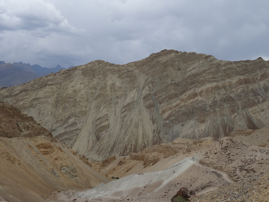
At Lamayuru, I bump into Pierre again in the company of a French couple who are travelling by car. I spend some time in the Gompa and also get a birds eye view of the "moon scape" of Lamayuru.

The "moon scape" of Lamayuru
Getting back to Leh proves to be tougher than expected. There are no buses. After a long wait, I get a lift to Khalse.

Pierre and Uzi
Then follows a hair-raising journey with a Lama in a maruti 800 to Leh. After a close brush with a car with some Punjabi youth, Lama Dorje chases the offending car and forces it to pull up by the side of the road. It is a wonder that there is no violence when Dorje gives the youth a piece of his mind. Emerging unscathed from the encounter, the Lama drives like mad and drops me right in front of my guest house.

Postscript:

I met Uzi again in Leh a few days later. He had recovered fully and was trying a motorbike on which he planned to ride to Timosgang.


Himalayan Trek 8, Aug 2013

Wednesday, September 28, 2016

Jalsu Pass trek diary - June 2016

The Plan

The Jalsu pass route is a well used trek route to cross the Dhauladhar range separating the Kangra and Ravi valleys. Minakshi Chaudhry in her well known "Guide to trekking in Himachal" lists this as an easy trek taking three days.

Binwa project site above Uttarala
My plan was to take a bus from Delhi to Baijnath on the night of 3rd June, visit Uttarala village on the 4th using Baijnath as base to find a guide and start the trek on 5th. I had planned the trek in 3 stages - Baijnath to Pari (8 km), Pari to Yada Goth over Jalsu pass (13 km) and Yada Goat to Laakewali Mata via Surai (10 km) followed by a bus to Holi.

This was to be a lightweight trek as there would be only two of us to carry the load. In terms of equipment, besides my personal clothes, utensils, sleeping bag and mattress, I carried a two man tent, a multi-fuel stove, 1.5 liter pressure cooker and an aluminium pot and frying pan. The list of items with weight is listed at the end of this post. Provisions and fuel would weigh over and above this. The only food items I was carrying was some emergency tail mix and dried vegetables.

4th June: Baijnath - Uttarala - Baijnath


View near Baklud
I reach Baijnath around 10 am and pick a hotel some distance from the bus stand. It is not the ideal choice as there is a half km walk to catch any bus. It is very hot in Baijnath and the walk to the hotel with the loaded backpack is tiring. Back at the bus stand, I find out that  I will get a bus to Uttarala only after a couple of hours. Second mistake of the day - I go back to the hotel and sleep. Finally I am on the 3pm bus to Uttarala. Just short of the village, there is road work in progress and the bus can go no further. I meet a shopkeeper who says he will guide me to the 'colony' where we will be able to find a guide.

It is about 4.30pm by the time we reach the colony of the Binwa hydro electric project. There are a few shops just inside the entry gate and we head to one of them. I explain my plan to a small audience of shopkeepers and this is then repeated by others to anyone who comes by. In a little while the shopkeepers zero in on a potential guide and contact him.


Raj Kumar
Raj Kumar is a daily wager who operates a machine that is used to lift concrete to higher floors in buildings under construction. He worked as a driver in Delhi but came back because he missed his family. Currently he lives just near the Uttarala colony.  He also has a little land. His ancestors were shepherds and his father worked in a factory in Punjab. The family unfortunately missed out on jobs in the hydro electric project.

We agree on a sum of 3000 Rs as his wage for accompanying me for three days from Baijnath to Holi. (Daily wage of Rs 800 + 600 for bus back). It is past 6 pm and I have missed the last bus back to Baijnath. A shopkeeper with a maruti drops me part of the way after which I walk an hour or so to reach my hotel.

5th June: Baijnath - Uttarala - Khodtru Dhar


Morning view, Khotru Dhar
I take a bus early morning and reach Uttarala. Raj Kumar is waiting for me. We pick up provisions at the Lala's - rice, dal, salt, potatoes, onion and dalia. Raj Kumar manages to get a bottle of Kerosene. We also get eggs from a dhaba and I stop to have breakfast. This is today's first mistake. It is 9.15 by the time we are ready and we have missed the company vehicle that would have given us a free lift to the dam site.

I hand over the tent, cooking equipment and supplies to Raj Kumar to carry while I carry my personal belongings. It takes us 2 hours to walk up to the dam site which falls on the trail to Jalsu. The government built dam is now over 40 years old. We pass by a water source. Raj Kumar convinces me not to fill my bottle as there is plenty of water on the way. This is today's second mistake.


Trail along the Binwa beyond Khotru Dhar
The third mistake follows soon. We follow an unpaved road that circles an enormous hill instead of taking the shortcut going up. This road is what remains of an ambitious but ill fated plan the government had of building a road over the Jalsu pass. Raj Kumar it turns out has been only once before on this route. After following the road for perhaps a km waiting for it to double back we decide to return and find the foot trail. The misadventure costs us at least an extra half hour.

We reach Baklud at 12 and I am parched by now. The water source here has completely dried up. A dhaba normally operates here but because of lack of water, there is no food being cooked. The dhaba owner is kind enough to give us some water from his personal stock.


Cave shelter at Jamad
Further on, we are caught in rain and hail. My rain coat proves quite useless and I am drenched. The trail follows the Binwa river upstream to its source. We reach a place called Khotru Dhar, some distance short of Parai around four. There is a single dukaan. We stop for some tea and the owner turns out to be related to Raj Kumar. It is wet outside and there is no good camping spot nearby. So we decide to sleep in the dukaan that night.

Dinner is rajma chawal and boiled eggs. I cannot sleep that night because of the smoke in the spare room next to the kitchen. The night stay and food costs us Rs 400. Raj Kumar's relative has charged us liberally.

Approaching Jalsu pass
6th June: Khodtru Dhar - Jamad camp (2900 m)

We start at 7 next morning after a breakfast of aluroti and tea and reach Parai with its three dhabas an hour later. We do not stop. After wading through a stream ( this must be the Binwa) we reach a place my guide calls Kharli right at the base of the mountain where Jalsu is located. It is already 11.30. A steep zig zag climb follows. It is 1 pm when we spot a cave which is a possible site for a tent. There is a water spring nearby. It is too late to attempt Jalsu today - so we decide to call it a day here.

It is a tight squeeze under the cave and it takes a bit of doing to set up the tent. The rest of the day is spent in cooking and resting. There is rain at night and a rat trying to get at our rations and that keeps me awake for the most part.


Jalsu Pass
7th June: Jamad camp (2900m) - Jalsu pass (3500m) - Channi camp


On the way to Yada Goat
We start at 7.30 after a breakfast of dalia and eggs and reach Jalsu top by 9.30. At the top are to be seen sheep and a couple of shepherds. After spending a half hour or so resting and taking in the views, we start our descent. The first obstacle is a frozen stream that has to be crossed extremely carefully. A slip will take one down rapidly. We reach Jalsu ka Paddar - a wide green pasture by 10.30. It is a nice walk from there on up to Yada Goth which we reach by 1 pm.

We stop at a dhaba across from the ramshackle government lodge. The dhaba owner, Bikham Lala, prepares a delicious kadi/rice which serves as our lunch. The view from his place is stupendous. The Lala stays here alone 6 months of the year. Among his other sources of income is money from selling Nag Chattri, a jadi booti. It fetches Rs 1600/kg in the Amritsar market and is bought by thekedars. We enjoy a drink of delicious chach.


Trail to Yada Goat
We resume our trek at 2.30 and after crossing the Channi nallah, reach Channi, a camping site with a single dhaba by 4.30. It is a nice walk from Yada Goat to Channi with expansive views of the valley sloping down to the Ravi. The route used by the public is not maintained by the Forest Department. Instead they have built a road along a distant ridge for exclusive use which they keep in good repair.

We pitch our tent outside the dhaba in Channi. An old couple lives there and caters to the needs of travellers. Lala says he has a "machine" implanted in his chest. The operation was done at the PGI in Chandigarh and cost 1.5 lakhs. (The "machine" is probably a pacemaker) He owns a flock of 100 sheep which his son looks after. They have houses in Surai village on the Ravi side and in Paprola in the Kangra valley. They have apple trees and cows but still operate this dhaba for additional income. Their main customers are the khacchar runners and pilgrims heading for Manimahesh. We have dinner with the couple.


Temple at Yada Goat
khacchar gang arrives just before we retire and keeps us awake the whole night. We fear that one of the khachars will run over our tiny tent. The five runners - all in all a rough bunch - keep making wild noises and flashing their torches throughout the night to drive away wild animals which are a threat to their khacchars. They pack up and leave at the crack of dawn.

8th June: Channi camp - Lake Mata Wali - Holi

We cook a khichidi of rice and dal in under 10 mins, eat and set off on a narrow path hewn in the rock face. On the way, Raj Kumar takes a detour to get some lovely chach from a villager. People here don't charge for chach.They have plenty of milk because of the cattle and chach that cannot be used soon is thrown away.

A clump of pine before Channi
As we progress down the valley, the Manimahesh range is visible framed by hills on either side of the valley. To our left are the Dhauladhars standing across Palampur. Far in the distance, the village of Bajol located across the Ravi can be seen.

The first village we pass by is Surai. The village has a guest house and is located at some height above the main trail to Laake Wali temple. A trail to Bara Bhangal takes of from Surai and leads to a point where the Ravi is crossed on a rope trolley.

Approaching the temple, we are in for a steep descent to cross the Channi nallah over a narrow bridge followed by a steep ascent. The bus timings for Holi from Laake Wali are 9am, 11am and 3 pm. There is plenty of time for the next bus. We order lunch at the dhaba which gets cooked and eaten over the next hour.


The Lala, Channi

The temple overlooks on one side the nallah which we just crossed; on the other side one gets a sheer view of a construction site of the Bajoli - Holi hydro electric project on the Ravi river being executed by GMR. GMR also seems to be carrying out work on a building right under the temple complex - project trucks ferry building material and workmen.


--------------------------------------------------------------------------------------
A video of the protest by women of Holi against this GMR project


--------------------------------------------------------------------------------
Around 2, I bid adieu to Raj Kumar and he sets out walking the trail we have come on. In a short while I spot him heading upwards across from the river. I learn later that he reached Yada Goat that night. The next day he took the ridge to the right of Binwa river and reached Tar village - the place of his in laws - by nightfall.


Laake Wali Mata Temple from across the Channi Nala
I catch the 3 pm bus and get off at the bridge over a stream flowing into the Ravi at Holi. The PWD has a large guest house just over the bridge where I find accommodation for the night.

Himalayan Trek 15, June 2016


Postscript

1. If you would like to hire Raj Kumar as a guide please contact him at 9805686205.

2. List of items I carried with weight in gms. This excludes weight of provisions and fuel.

ITEM                                                                                                                    Weight

Rucksack (60l)1715
Rain cover165
Tent (2man)2250
Sleeping bag1560
mat150
trekking pole250
Rain jacket (white), plastic bags150
Zip Jacket - Down900
Woolen monkey cap90
Cotton top, bottom ( Pant 285, Kurta(145), T shirt (115))545
slippers240
Track Pant/ T shirt, trunks, socks, (cap, shoes, knee caps) - wearing0
Extra Socks ( 3 pairs, 165), shorts ( 2 pairs, 205)370
Fleece pullover310
Towel80
Daypack170
Camera280
Diary/Pen/reservation slips/money/cards/mobile/torch/route maps/provision list290
Med Kit100
Toilet kit        -Tooth brush (35), paste (35), hand/paper soap(30), sunscreen (40), empty bottle, toilet paper150
Spares/repair kit-    spare batteries (camera (40), torch(40)), charger (100), old newspaper, needle, thread, rubber band, adhesive, safety pin190
Burner, pump, oil container, carabiner, rags, windscreen, match box680
Cooking pot with cover ( tea, store dal,veg)290
Ladle, knife, spoon, egg holders, scrubber120
Pressure cooker910
Personal Utensils-  Spoon,fork, tumbler,plate                                                               130
Water bottle, carabiner190
Food ( dried vegetables), ziploc bags160
Emergency Trail mix150
TOTAL WEIGHT =12530


Sunday, February 21, 2016

Drilbu Ri and Keylong

While in Keylong, I have been visiting the Pau Gomba Sanju Dhaba morning and evening. In external appearance it is quite undistinguished, but as I have discovered, the atmosphere inside is friendly, the kitchen clean and open, the food tasty and the staff willing to cater to my little whims.


(This piece is reproduced from EPW, Jan 30, 2016. Pictures added)


Keylong seen from the base of Drilbu Ri
Pasang Dolma runs the dhaba with a male assistant and her two younger sisters. The food is priced reasonably, and the dhaba does roaring business. Despite keeping long hours – 6.30 in the morning to 10.30 at night - Pasang remains cheerful and is always ready to engage in friendly banter with acquaintances that drop in. And as for me, I have found the information she has provided about excursions around town to be very useful.

Today I plan to do the kora (parikrama) of Drilbu Ri (Bell Mountain), a formidable mountain that towers over Keylong. The kora regularly attracts pious Buddhists and Hindus and occasionally the not so pious trekkers like me. Pasang informs me that it is a long and hard trek and people start by 5 am. I get off to a late start - it is past 7.30 by the time I have eaten and packed some food for the way.

Fire Fronted Serin
I walk through the town and follow a path out past fields of peas, cauliflower and potato. The path slopes down to a bridge spanning the narrow gorge of the Bhaga and then climbs steeply to the Khardang gompa (monastery). School children run down past me while I make heavy work of the climb. One of them informs me he has completed the kora twice and that leaves me reassured. Just beyond the gompa, I stop at a spring to catch my breath and watch the sparrow sized birds - Fire Fronted Serin - that flit about near the water.

The ramparts of the fortress like Drilbu Ri loom above, its grassy flanks streaked with pink Himalayan Fleece. The sun and clouds play with the hills to produce strange patterns of light and shadow over the valley. The path climbs up the side of the mountain and is marked with flags, painted rock signs and cairns.

First sight of prayer flags on Rangcha Gali
 It turns out to be a long and lonely walk. In the three hours elapsed after passing the gompa, the only person I see is an old man so engrossed in his prayers that he walks by without looking at me. The trek down - if I have to return the same way - is going to be tougher, for the path is steep and slippery in many places. I harbour thoughts of turning back.

Not a minute too soon, the prayer flags marking the pass come into view. With newfound energy, I cover the stiff remaining climb to reach Rangcha Gali, a narrow passage to the other side of Drilbu Ri, skirting its commanding heights. My altimeter shows 4380 m. I have gained nearly 1.5 km height from the time I walked on the bridge over the Bhaga!

I sit down and feast my eyes over the panorama. The majestic Pir Panjals stretch out east and west as far as the eye can see, mingling with the clouds. Directly across from me, the 6000 m Shikar Beh and Mukar Beh rise vertically from the Chandra River 3 km below.

Ridge separating Chandra and Bhaga watersheds, 4380 m
 The view over the side of the mountain that I just came up is no less enchanting. Pretty Keylong lies spread out at the bottom of the Bhaga valley against the backdrop of imposing hills. Visible through a gap in the hills, is Zanskar, a forbidding world of snow and glaciers.

Colourful prayer flags flutter in the wind and chortens adorn the ridge separating the Chandra and Bhaga valleys. Next to a chorten, a small yellow tin shed serves as a temple. I spot a gaddi perched on a rock from where he can keep an eye on his flock that is somewhere below. He throws a remark at me - "so you have reached" and offers me a slice of fruit that he is eating. My ascent must have appeared to him excruciatingly slow.


Shikar Beh and Mukar Beh ( both 6000 m +)
Higher up on the ridge, I come across a large group of monks in red. They are students of the Tibetan School of Medicine in Sarnath belonging to different Himalayan geographies - Nepal, Sikkim, Bhutan and Ladakh – here on an excursion. I did not run into them so far as they left Keylong much earlier than me.

It is an easy descent into the Chandra valley and in a couple of hours I reach the Manali - Leh highway. A bus takes me along the Chandra downstream to its confluence with the Bhaga and then along the Bhaga upstream to Keylong. I head straight for the comforts of the Pau Gomba Sanju Dhaba. Pasang Dolma is not surprised to hear that I completed the kora - "he walks fast", she tells her co-workers.


Pasang is ethnically Tibetan like many Lahoulis and I have assumed that she is Lahouli too. In conversation, I discover that she belongs to Nepal, to the village of Listi near the Chinese border. So does her assistant. Their village is known for the Pau Gompa and they have named their dhaba after it. Who is there in the village, I ask her. My son and my in-laws, Pasang replies. 'Sab kuch hai ghar me – makaan, kheti, gaadi’.

Pasan Dolma (center)
Pasang is familiar with Delhi and this intrigues me. With more questions I uncover the amazing seasonal migration of this family. With the coming of winter before the road to Keylong becomes snow bound, they move to Delhi to carry on a different trade - selling Nepali woollens. When winter is over, they return home to Nepal. (There is even a direct bus service from Majnu ka tila where they live while in Delhi to their village, Listi!) Come summer, when the Manali - Leh road opens, they are back in Keylong running the dhaba. I ask the family if they ever take a holiday and get a short retort - ours is not a government job!

It is time for me to leave Keylong and I stop by at the dhaba one last time. Pasang Dolma asks me to visit again. I am not being just polite when I tell her I will.